You can
sponsor
this page
Common name (e.g. trout)
contains
begins with
begins with
ends with
is
Genus + Species (e.g. Gadus morhua)
About this page
More Info
Plus d'info
Mais info
Languages
Arabic
Bahasa/Malay
Bangla
Chinese(Si)
Chinese(Tr)
Deutsch
English
Español
Farsi
Français
Greek
Hindi
Italiano
Japanese
Lao
Nederlands
Português(Br)
Português(Pt)
Russian
Swedish
Thai
Vietnamese
User feedbacks
Comments &
Corrections
Fish Forum
Guest Book
Facebook
Citation
Uploads
Attach website
Upload photo
Upload video
Upload
references
Fish Watcher
Related species
Species in
Masturus
Species in
Molidae
- Classification -
Molidae
Tetraodontiformes
Teleostei
Chordata
Animalia
Masturus
lanceolatus
(Liénard
, 1840)
Sharptail mola
Add your observation in
Fish Watcher
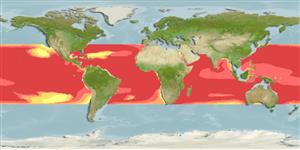
Native range
|
All suitable habitat
|
Point map
|
Year 2050
This map was computer-generated and has not yet been reviewed.
Masturus lanceolatus
AquaMaps
Data sources:
GBIF
OBIS
Upload your
photos
and
videos
Pictures
|
Google image
Masturus lanceolatus
Picture by
The Fish Database of Taiwan
Senegal country information
Common names:
[No common name]
Occurrence:
native
Salinity:
marine
Abundance:
|
Ref:
Importance:
|
Ref:
Aquaculture:
|
Ref:
Regulations:
|
Ref:
Uses:
no uses
Comments:
Known from Dakar (Ref. 6952).
National Checklist:
Country Information:
https://www.cia.gov/library/publications/resources/the-world-factbook/geos/sg.html
National Fisheries Authority:
http://www.refer.sn/sngal_ct/eco/oeps/
Occurrences:
Occurrences
Point map
Main Ref:
Tortonese, E., 1990
National Database:
Common names from other countries
Poisson-lune lancéolé
,
Sharpfin sunfish
,
Sharptailed sunfish
,
... more
Classification / Names
Common names
|
Synonyms
| Catalog of Fishes(
genus
,
species
) |
ITIS
|
CoL
|
WoRMS
|
Cloffa
Teleostei (teleosts) >
Tetraodontiformes
(Puffers and filefishes) >
Molidae
(Molas or Ocean Sunfishes)
Etymology:
Masturus:
Greek, mastax, -agos = bite + Greek, oura = tail (Ref.
45335
)
.
Environment: milieu / climate zone / depth range / distribution range
Ecology
Marine; brackish; bathypelagic; depth range ? - 670 m (Ref.
36453
). Deep-water; 37°N - 35°S
Distribution
Countries
|
FAO areas
|
Ecosystems
|
Occurrences
|

")