Common names:
Pating
Occurrence:
native
Salinity:
marine
Abundance:
|
Ref:
Importance:
subsistence fisheries
|
Ref:
Aquaculture:
|
Ref:
Regulations:
|
Ref:
Uses:
no uses
Comments:
Misidentified by Herre (Ref. 280) as Hexanchus griseus; two Dumaguete specimens SU 30642. Also collected from Dipolog City market and Isla Verde, Pulu, Dapitan City (Ref. 47737). Occurrence based on map distribution (Ref. 125614). Also Ref. 247, 13573.
National Checklist:
Country Information:
https://www.cia.gov/library/publications/resources/the-world-factbook/geos/rp.html
National Fisheries Authority:
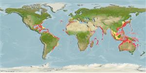
Occurrences:
OccurrencesPoint map
Main Ref:
Compagno, L.J.V., P.R. Last, J.D. Stevens and M.N.R. Alava, 2005
National Database:
Elasmobranchii (sharks and rays) > Hexanchiformes (Frill and cow sharks) > Hexanchidae (Cow sharks)
Etymology: Hexanchus:hex (Gr.), six; anchus, etymology unclear, perhaps anchos (Gr.), choke or throttle, referring to how six gill openings of H. griseus extend down onto the throat. (See ETYFish); nakamurai:In honor of Teng’s colleague Hiroshi Nakamura, Fisheries Experiment Station of the Government-General during the Japanese occupation of Taiwan, who illustrated this species as H. griseus in 1936. (See ETYFish).
Environment: milieu / climate zone / depth range / distribution range
Ecology
Marine; bathydemersal; depth range 0 - 700 m (Ref. 125614), usually 90 - 600 m (Ref. 6574). Deep-water; 33°N - 36°S, 30°E - 178°W
Distribution
Countries | FAO areas | Ecosystems | Occurrences | Fatal error: Uncaught mysqli_sql_exception: Table 'fbapp.scientificname' doesn't exist in /var/www/html/includes/speciessummary.lib.php:2366
Stack trace:
#0 /var/www/html/includes/speciessummary.lib.php(2366): mysqli->query()
#1 /var/www/html/country/CountrySpeciesSummary.php(1228): checkPointMApDisplay()
#2 {main}
thrown in /var/www/html/includes/speciessummary.lib.php on line 2366

")