You can
sponsor
this page
Common name (e.g. trout)
contains
begins with
begins with
ends with
is
Genus + Species (e.g. Gadus morhua)
About this page
More Info
Plus d'info
Mais info
Languages
Arabic
Bahasa/Malay
Bangla
Chinese(Si)
Chinese(Tr)
Deutsch
English
Español
Farsi
Français
Greek
Hindi
Italiano
Japanese
Lao
Nederlands
Português(Br)
Português(Pt)
Russian
Swedish
Thai
Vietnamese
User feedbacks
Comments &
Corrections
Fish Forum
Guest Book
Facebook
Citation
Uploads
Attach website
Upload photo
Upload video
Upload
references
Fish Watcher
Related species
Species in
Terapon
Species in
Terapontidae
- Classification -
Terapontidae
Centrarchiformes
Teleostei
Chordata
Animalia
Terapon
jarbua
(Fabricius
, 1775)
Jarbua terapon
Add your observation in
Fish Watcher
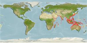
Native range
|
All suitable habitat
|
Point map
|
Year 2050
This map was computer-generated and has not yet been reviewed.
Terapon jarbua
AquaMaps
Data sources:
GBIF
OBIS
Upload your
photos
and
videos
Pictures
|
Videos |
Google image
Terapon jarbua
Picture by
Cook, D.C.
Kenya country information
Common names:
Ngagu
,
Thornfish
Occurrence:
native
Salinity:
brackish
Abundance:
|
Ref:
Importance:
|
Ref:
Aquaculture:
|
Ref:
Regulations:
|
Ref:
Uses:
live export: yes;
Comments:
A coastal and mangrove species which enters lower parts of rivers (Ref. 52331).
National Checklist:
Country Information:
https://www.cia.gov/library/publications/resources/the-world-factbook/geos/ke.html
National Fisheries Authority:
http://www.recoscix.org/openscrn.htm
Occurrences:
Occurrences
Point map
Main Ref:
Seegers, L., L. De Vos and D.O. Okeyo, 2003
National Database:
Common names from other countries
Violon jarbua
,
细鳞鯻
,
Crescent-banded grunter
,
... more
Classification / Names
Common names
|
Synonyms
| Catalog of Fishes(
genus
,
species
) |
ITIS
|
CoL
|
WoRMS
|
Cloffa
Teleostei (teleosts) >
Centrarchiformes
(Basses) >
Terapontidae
(Grunters or tigerperches)
Etymology:
Environment: milieu / climate zone / depth range / distribution range
Ecology
Marine; freshwater; brackish; demersal; catadromous (Ref.
51243
); depth range 20 - 350 m (Ref.
58488
). Tropical; 26°C - 29°C (Ref.
4959
); 36°N - 35°S, 20°E - 167°W
Distribution
Countries
|
FAO areas
|
Ecosystems
|
Occurrences
|

")