You can
sponsor
this page
Common name (e.g. trout)
contains
begins with
begins with
ends with
is
Genus + Species (e.g. Gadus morhua)
このページについて
More Info
Plus d'info
Mais info
言語
Arabic
Bahasa/Malay
Bangla
Chinese(Si)
Chinese(Tr)
Deutsch
English
Español
Farsi
Français
Greek
Hindi
Italiano
Japanese
Lao
Nederlands
Português(Br)
Português(Pt)
Russian
Swedish
Thai
Vietnamese
User feedbacks
Comments &
Corrections
魚のフォーラム
ゲストブック
Facebook
引用
Uploads
ウェブサイトを付け加えて下さい
写真をアップロード
ビデオをアップロード
Upload
references
Fish Watcher
近縁種
種
Decapterus
種
Carangidae
- 分類 -
Caranginae
Carangidae
Carangiformes
Teleostei
Chordata
Animalia
Decapterus
tabl
Berry
, 1968
Roughear scad
個人による観察記録の追加
Fish Watcher
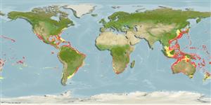
Native range
|
All suitable habitat
|
Point map
|
Year 2050
This map was computer-generated and has not yet been reviewed.
Decapterus tabl
AquaMaps
Data sources:
GBIF
OBIS
Upload your
写真
and
ビデオ
Pictures
|
グーグルの画像
Decapterus tabl
Picture by
Trevor, M.
Saint Helena Island country information
Common names:
Greater Kingston
,
Kingston
,
Redtail scad
Occurrence:
native
Salinity:
marine
Abundance:
|
Ref:
Importance:
|
Ref:
Aquaculture:
|
Ref:
Regulations:
|
Ref:
Uses:
no uses
Comments:
National Checklist:
Country Information:
https://www.cia.gov/library/publications/resources/the-world-factbook/geos/sh.html
National Fisheries Authority:
Occurrences:
Occurrences
Point map
Main Ref:
Smith-Vaniz, W.F., J.-C. Quéro and M. Desoutter, 1990
National Database:
Common names from other countries
Comète queue rouge
,
Macarela rabo colorado
,
نيزكة حمراء الذيل
,
... more
分類 / Names
共通名の
|
類義語
| Catalog of Fishes(
部類
,
種
) |
ITIS
|
CoL
|
WoRMS
|
Cloffa
>
Carangiformes
(Jacks) >
Carangidae
(Jacks and pompanos) > Caranginae
Etymology:
Decapterus:
Greek, deka = ten + Greek, pteron = wing, fin (Ref.
45335
)
.
Environment: milieu / climate zone / depth range / distribution range
生態学
海
底生の;
深さの範囲
7 - 550 m (Ref.
47377
), usually 150 - 220 m (Ref.
5217
). Subtropical; 45°N - 55°S, 102°E - 41°E
分布
国々
|
国連食糧農業機関の区域
|
エコシステム
|
事件
|
Fatal error
: Uncaught mysqli_sql_exception: Table 'fbapp.scientificname' doesn't exist in /var/www/html/includes/speciessummary.lib.php:2366 Stack trace: #0 /var/www/html/includes/speciessummary.lib.php(2366): mysqli->query() #1 /var/www/html/country/CountrySpeciesSummary.php(1228): checkPointMApDisplay() #2 {main} thrown in
/var/www/html/includes/speciessummary.lib.php
on line
2366

")