You can
sponsor
this page
Common name (e.g. trout)
contains
begins with
begins with
ends with
is
Genus + Species (e.g. Gadus morhua)
關於這一頁
More Info
Plus d'info
Mais info
語言
Arabic
Bahasa/Malay
Bangla
Chinese(Si)
Chinese(Tr)
Deutsch
English
Español
Farsi
Français
Greek
Hindi
Italiano
Japanese
Lao
Nederlands
Português(Br)
Português(Pt)
Russian
Swedish
Thai
Vietnamese
User feedbacks
Comments &
Corrections
魚類討論區
留言版
Facebook
引用出處
Uploads
附上網站
上傳相片
上傳影像
Upload
references
Fish Watcher
相關魚種
魚種在
Myliobatis
魚種在
Myliobatidae
- 分類 -
Myliobatidae
Myliobatiformes
Elasmobranchii
Chordata
Animalia
Myliobatis
goodei
Garman
, 1885
Southern eagle ray
把你的觀察加入
Fish Watcher
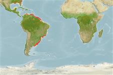
Native range
|
All suitable habitat
|
Point map
|
Year 2050
This map was computer-generated and has not yet been reviewed.
Myliobatis goodei
AquaMaps
Data sources:
GBIF
OBIS
上傳你的
相片
和
影像
Pictures
|
Google 影像
Myliobatis goodei
Picture by
INIDEP
Guyana country information
Common names:
[No common name]
Occurrence:
native
Salinity:
marine
Abundance:
|
Ref:
Importance:
|
Ref:
Aquaculture:
|
Ref:
Regulations:
|
Ref:
Uses:
no uses
Comments:
National Checklist:
Country Information:
https://www.cia.gov/library/publications/resources/the-world-factbook/geos/gy.html
National Fisheries Authority:
http://www.sdnp.org.gy/minagri/mofc&l/Fisheries/fisheries_department.htm
Occurrences:
Occurrences
Point map
Main Ref:
Cervigón, F., R. Cipriani, W. Fischer, L. Garibaldi, M. Hendrickx, A.J. Lemus, R. Márquez, J.M. Poutiers, G. Robaina and B. Rodriguez, 1992
National Database:
Common names from other countries
Aigle de mer du sud
,
Southern eagle fish
,
Aigle de mer chuche
,
... more
分類 / Names
俗名
|
同種異名
| Catalog of Fishes(
屬
,
種
) |
ITIS
|
CoL
|
WoRMS
|
Cloffa
Elasmobranchii
板鰓亞綱 (鯊魚與魟魚) (sharks and rays)
>
Myliobatiformes
(Stingrays)
鰩目 (Stingrays)
>
Myliobatidae
(Eagle and manta rays)
燕魟科 (Eagle and manta rays)
Etymology:
Myliobatis:
Greek, mylo = mill + Greek, + Greek, batis,-idos = a ray (Raja sp.) (Ref.
45335
)
.
More on author:
Garman
.
Environment: milieu / climate zone / depth range / distribution range
生態學
海洋
底中水層性;
深度上下限
1 - 130 m (Ref.
57911
). 熱帶; 33°N - 40°S, 180°W - 180°E
分布
國家
|
FAO區域
|
生態系
|
發現紀錄
|
Fatal error
: Uncaught mysqli_sql_exception: Table 'fbapp.scientificname' doesn't exist in /var/www/html/includes/speciessummary.lib.php:2366 Stack trace: #0 /var/www/html/includes/speciessummary.lib.php(2366): mysqli->query() #1 /var/www/html/country/CountrySpeciesSummary.php(1228): checkPointMApDisplay() #2 {main} thrown in
/var/www/html/includes/speciessummary.lib.php
on line
2366


")